|
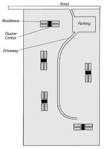
Preliminary Site Plan This diagram shows a typical configuration for a 19-acre property. This diagram represents a property with 680 feet of road front and 1,206 feet of depth. The road is shown by the open rectangle at one end of the property. It is likely to be a gravel road. We expect to have parking near the road, as shown by the white area near the road. We expect to cluster the buildings so that green-space vistas are maximized, and to form a second level of social structure above the household. Each cluster will have a cluster center. The diagram shows one possible layout of residences (medium dark) and cluster centers (darker), each of which is a building 30 feet wide by 65 feet long. Each building would thus have 1,950 square feet. The space between buildings in a cluster is five feet. Thus each cluster is a rectangle 65 feet wide by 170 feet long. A "driveway" suitable for very occasional use by vehicles would wind from the parking area between the clusters. It would be formed by a light layer of gravel with a strongly rooted grass growing around the gravel. Paths which appeared spontaneously due to common use would be paved.
 Home |
